
Pipeline Trail - Church Creek to Pipeline Overlook
Outdoors & Recreation
About Pipeline Trail - Church Creek to Pipeline Overlook
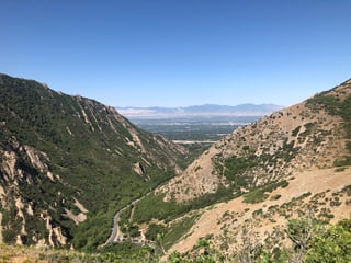
Longer hike with beautiful canyon and city views. Easier and family-friendly with little altitude change.
A moderate to heavily trafficked hike on the popular Pipeline Trail with beautiful canyon views. The first mile (and last, as this is an out-and-back trail) are well shaded, but the rest is in the sun, so bring a hat and sunscreen, as well as plenty of water. The trail follows the canyon for many miles in both directions from the trailhead, and it follows it a few hundred feet up on the north slope of the canyon - but it is largely a flat trail with little elevation change. Views are spectacular all along the trail and particularly at the overlook, which takes in the Salt Lake Valley.
Local's recommendation: An excellent spring, summer, or fall hike. Dogs are allowed; they must be kept on-leash on even days, and can be off-leash on odd days.
Details
Difficulty: Easy
Highest point: 6037 ft
Lowest point: 5699 ft
Best time of year: Spring, Summer, Fall
Safety information: As with any trail in the foothills, watch for rattlesnakes, especially in summer months. Wear closed-toed shoes when hiking, be aware of your surroundings, and always look carefully before placing hands or feet.
Be aware of bikes - this is also a popular trail for mountain bikers and they are allowed on the trail year-round.
Roadbook
From the Church Fork Picnic Area, follow the road up the mountain to the Grandeur Peak trailhead. Follow this trail to where the Pipeline Trail crosses the Grandeur Peak trail. Turn left on the Rattlesnake Gulch section of the trail, and follow it to the Pipeline Overlook.
- Church Fork Picnic Area, 5802 Mill Creek Canyon Rd, Salt Lake City, UT 84109 - 0 mi
- Pipeline Overlook - 3.5 mi
- Highest point, 6033 ft - 4.3 mi
- Lowest point, 5699 ft - 7.1 mi
- Pipeline Overlook - 7.1 mi
How to Get There
Public transport: Bus routes do not travel up to this trail head - best access is by car.
Parking: There is some limited, but free parking at the trailhead. Parking at the Church Fork Picnic Area is reserved for those using the picnic area. There is also free parking on the canyon road. Be aware that there is a $5.00 fee when exiting Millcreek Canyon.
Quick Links

Near Pipeline Trail - Church Creek to Pipeline Overlook
- Grandeur Peak from the East Trail via Church ForkEntertainment
- Thaynes Canyon LoopEntertainment · 0.1 mi
- Log HavenFood & Drink · 1.9 mi